船舶用製品
quatix 6X Dual Power

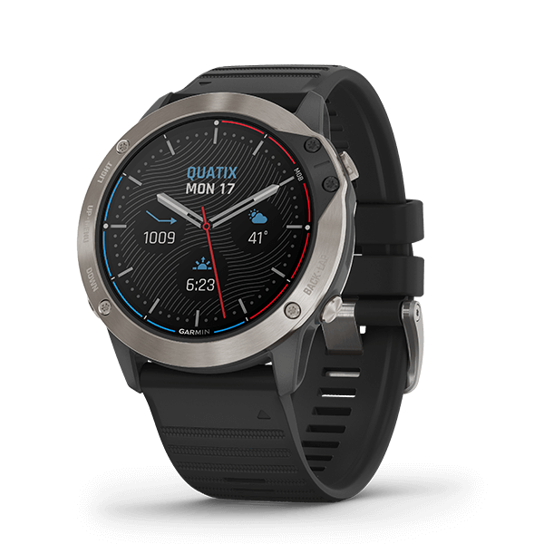
quatix 7
マリン機能搭載 マルチスポーツGPSスマートウォッチ

STRIKER Cast GPS
スマートデバイスを魚群探知機として使用できるGPS搭載キャスタブルソナー

STRIKER Cast
スマートデバイスを魚群探知機として使用できるキャスタブルソナー

AIRMAR B275LH

Garmin GT50M-THP

Garmin GT50M-TH

Garmin GT50M-TM

Garmin GT40-TM

Garmin GT41-TM

Garmin GT41-TH

Garmin GT41-THP

GPSMAP 1222xsv Touch

GPSMAP 1222 Touch

VHF 210 Marine Radio

GNX Wireless Sail Pack 52

gWind Race/nWind Connector Adapter Cable Bundle

gWind/nWind Connector Adapter Cable Bundle

9-axis Heading Sensor

gWind Wireless Transducer Bundles

GMI/GNX Wired Sail Pack 52-CLOSE

quatix 6 Sapphire
GPSMAP 1222xsv Plus
SideVü, ClearVü and Traditional CHIRP Sonar with Worldwide Basemap
GPSMAP 1222 Plus
Non-sonar with Worldwide Basemap

GPSMAP 922 Plus
Non-sonar with Worldwide Basemap

GPSMAP 722 Plus
Non-sonar with Worldwide Basemap

Panoptix LiveScope LVS12 Transducer

quatix 5 Sapphire
対応Garminチャートプロッタおよびその他のデバイスと接続し、速度、深度、温度、風などのデータをquatix 5 Sapphireウォッチにストリーミングします。傷がつきにくいサファイアレンズと素早く交換できるバンドが特徴のコンパクトでスタイリッシュなウォッチは、高度なフィットネス機能と光学式心拍計機能もサポートしています。quatix 5 Sapphireは、ビルトインのアクティビティプロファイルおよびパドルボーディング、水泳、カヌーのパフォーマンスデータ機能で、あらゆるスポーツの追跡に対応します。

GC™ 12 Marine Camera

STRIKER™ Plus 7sv

STRIKER™ Plus 9sv

echoMAP™ Plus 75cv

echoMAP™ Plus 75sv

echoMAP™ Plus 95sv

echoMAP™ Plus 65cv

STRIKER™ Plus 7cv
STRIKER™ Plus 5cv

GC™ 100 Wireless Camera

GPSMAP® 722

GPSMAP® 722xs

VHF 110 Marine Radio

GPSMAP® 922xs

GPSMAP® 585
The GPSMAP 585 is a full-function chart plotter that features an ultra-bright 5” WQVGA color display along with an improved feature of high-speed map drawing and panning.

GPSMAP® 580
The GPSMAP 580 is a full-function chart plotter that features an ultra-bright 5” WQVGA color display along with an improved feature of high-speed map drawing and panning. It’s ready to go with an easy-to-use interface and a built-in worldwide basemap. The 580 is unique Garmin chart plotters that not only equip with English language but also with Asian languages including Simplified Chinese and Bahasa Indonesia. GPSMAP 580 is designed specifically for professional fishermen and comes with the advantages of Garmin’s renowned GPS168/178C chart plotters.

GPSMAP 7408
Get quality trackplotting with the high-sensitivity GPS 158, a grayscale trackplotter with easy-to-use features that fits both your boat and your budget.

echoMAP™ CHIRP 45cv

echoMAP™ CHIRP 75sv

echoMAP™ CHIRP 55cv

echoMAP™ CHIRP 95sv

12-pin Transducer Extension Cable (30 ft)

Bronze Thru-hull Mount Transducer with Depth, Speed & Temperature (Long Stem) - Airmar B744VL

Bronze Thru-hull Transducer with Depth & Temperature (20° tilt, 8-pin) - Airmar B75H

Plastic Thru-hull Mount Transducer with Depth & Temperature - Airmar 509LH

Stainless Steel Thru-hull Mount Transducer with Depth & Temperature (0° tilt) - Airmar SS164

Smart Thru-Hull Mount Transducer with Depth, Speed & Temperature (Triducer, NMEA 2000®) - Airmar DST800

Plastic Transom Mount Transducer with Depth & Temperature - Airmar TM265LM

Stainless Steel Thru-hull Mount Transducer with Depth & Temperature (12° tilt) - Airmar SS164

Portable Fishing Kit
Portable Fishing Kit

TR-1 Gold Marine Autopilot

VHF 300 AIS
The Garmin VHF 300 AIS marine receiver combines radio communication and 1 or 25 watts of transmit power with multi-station support to give you the flexibility and convenience you need to safely navigate and communicate on the open waters.

VHF 100i

GHS™ 20i

GHS 20i, GWH 20i Black Wireless

VHF 100 Marine Radio

GHS™ 20 Wireless VHF Handset

GNX™ Wind Wired Sail Pack

gWind™ Transducer Bundles

GPS 19x NMEA 2000®
The highly accurate GPS 19x NMEA 2000 position receiver/antenna provides 10 Hz update rates for position, velocity and time data. It offers high-sensitivity reception and enhanced position acquisition to the Garmin family of marine multifunctional displays (MFD), instrument display and autopilots.

GPS 19x HVS

AQUAMAP® 100xs
10" Keyed Chartplotter/Sonar Combo for Fishing

GPSMAP® 2108 Plus

GPSMAP® 78sc
For boaters and watersports enthusiasts who want to run with the best, the rugged GPSMAP 78sc includes preloaded U.S. coastal charts and features a 3-axis compass, barometric altimeter, crisp color mapping, a high-sensitivity receiver, new molded rubber side grips, plus a microSD™ card slot for loading additional maps. And it floats!

GPSMAP® 78s
For boaters and watersports enthusiasts who want to run with the best, the rugged GPSMAP 78s features a 3-axis compass, barometric altimeter, crisp color mapping, high-sensitivity receiver, new molded rubber side grips, plus a microSD™ card slot for loading additional maps. And it floats!

GPSMAP 78

GPSMAP® 7412xsv

GPSMAP® 7410xsv

GPSMAP® 7408xsv

GPSMAP® 7407xsv

日本湖川地図(無償)
チャートプロッター内蔵のベースマップでは湖川データは非常に粗く、湖沼や河川をフィールドにされている方には使いにくいかと思います。 無償の日本湖川地図をダウンロードしていただく事により詳細な湖沼や河川の地図が利用出来ます。